.jpg)

Damaging winds, heavy rainfall, hail the main threats . FLOOD WATCH Wed. afternoon to Thu. morning.
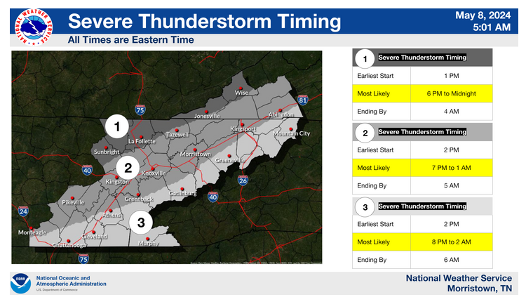
LAFOLLETTE, TN (WLAF) – Wednesday features a muggy, breezy day with more clouds than sun to go along with a high of 78. Several rounds of showers and storms are expected through Thursday morning. Some of these storms may become strong to severe this afternoon and evening with damaging winds, heavy rainfall and hail as the main threats. There is an enhanced risk of severe storms today and tonight.

Make sure you have a way to receive watches and warnings for severe weather.
An outbreak of severe weather is increasingly likely across much of the Mid-South, including into our area, Campbell County, from late this afternoon through tonight. All severe hazards are possible, including widespread damaging winds, very large hail to golf ball size or larger, and tornadoes, some of which could be strong. The tornado threat is highest along and west of Interstate 75.
In addition to the severe hazards, heavy rainfall is likely, due to many rounds of showers and storms. Scattered to possibly numerous instances of flooding are likely with the greatest threat along and west of Interstate 75. This threat will be most amplified from the evening until early Thursday morning.
There is a FLOOD WATCH from Wednesday afternoon through Thursday morning. Excessive runoff may result in flooding of rivers, creeks, streams, and other low-lying and flood-prone locations. Creeks and streams may rise out of their banks. Flooding may occur in poor drainage and urban areas.
You should monitor later forecasts and be alert for possible Flood Warnings. Those living in areas prone to flooding should be prepared to take action should flooding develop.
Turn around, don`t drown when encountering flooded roads. Most flood deaths occur in vehicles.
Flooding is a concern Wednesday night into Thursday for areas where repeated rainfall occurs. (WLAF NEWS PUBLISHED – 05/08/2024-6AM)