.jpg)
Bitter wind chills, single-digit lows and accumulating snow ahead this weekend
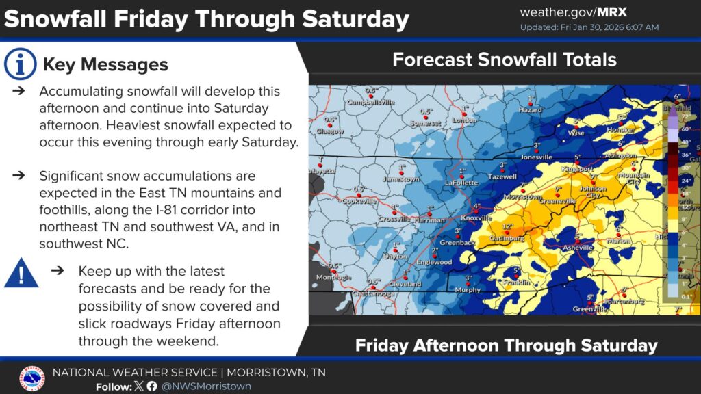
LAFOLLETTE, TN (WLAF)- Friday brings a cloudy, gray day with a high of 34. Snow is likely Friday, mainly after lunch time, and the snow will linger through late Saturday afternoon. A powerful Arctic blast arrives in Campbell County on Friday night as the low slips to 12 with a wind chill of -6.
Temperatures struggle to make it out of the teens (wind chills of -8) on Saturday during the day as snowfall will come and go. Snow moves out by late Saturday afternoon as total snow accumulations could reach as high as three-inches. Breezes will blow snow creating visibility challenges at times.
A low of eight is forecast for Saturday night to go along with a feels-like temperature of -7. The below zero wind chills linger through Sunday afternoon as cold sunshine and 20s round out the weekend. There is a COLD WEATHER ADVISORY from Saturday through early Sunday afternoon.
- WHAT…Snow expected. Total snow accumulations of one to three three inches possible.
- WHERE…Campbell County and a portion of East Tennessee.
- WHEN...From 1 PM Friday to 7 PM Saturday.
- IMPACTS…Plan on slippery road conditions. The hazardous conditions could impact the Friday evening commute.
- PRECAUTIONARY/PREPAREDNESS ACTIONS…Slow down and use caution while traveling. The latest road conditions for the state you are calling from can be obtained by calling 5 1 1. (WLAF NEWS PUBLISHED-01/30/2026-6AM-TEXT AND IMAGES COURTESY OF THE NWS MORRISTOWN)